
About
 View of the Itoshima Peninsula coastline from the Genkai Sea, showing the scenic coastal landscape that characterizes this driving route. Source: Wikimedia Commons
The Genkai Sea scenic drive encompasses the coastal perimeter of the Itoshima Peninsula, offering one of Kyushu's most spectacular seaside driving experiences. The route follows Prefectural Road 54, commonly known as "Shima Sunset Road," which stretches 33.3 kilometers from Benten Bridge at the mouth of the Izumikawa River to Sakurai Futamigaura. 🔗
This coastal route is part of Japan's prestigious Scenic Byways program, with the Genkai Sea Byway extending approximately 178 kilometers through Fukuoka, Itoshima, and Karatsu. The Itoshima section showcases the region's designation as part of Genkai Quasi-National Park, established June 1, 1956. The drive features winding roads that curve in and out of bays, creating constantly changing perspectives of the coastline. Well-maintained smooth roads, open flats, and scenery make the peninsula attractive for both drivers and cyclists. 🔗 🔗
Cultural & Geographic Significance
The Genkai Sea holds deep cultural importance in Japanese history and spirituality. The name "Genkai" comes from its position as the frontier between Japan and the Asian mainland—historically this was the gateway through which continental culture, Buddhism, and diplomatic missions arrived in Japan. The coastal route passes numerous ancient Shinto shrines that reflect this spiritual heritage, including sites where deities of safe sea passage and maritime prosperity are venerated. 🔗
The Itoshima Peninsula extends into the Genkai Sea at the northwestern edge of Fukuoka Prefecture, featuring a dramatic meeting of mountain and sea, with the Sefuri Mountains rising to the south while pristine beaches and rocky coastlines define the northern shores. 🔗
Route Information
Overview
- Total Distance: 33 km (Route 54 core section) to 80 km (complete peninsula loop)
- Drive Time: 2-4 hours depending on stops (Route 54: 45-60 min without stops)
- Road Type: Well-maintained prefectural highway, two-lane coastal road
- Difficulty: Easy - suitable for all driving abilities
- Traffic: Light to moderate; busier on weekends
- Best Season: Year-round accessible; November offers comfortable temperatures and excellent visibility
Access
From Fukuoka City:
- Approximately 30 minutes via toll road to eastern entrance
- About 1 hour total from Hakata Station to main scenic sections
Route Starting Points:
- Eastern entrance: From Fukuoka via National Route 202 or Nishi-Kyushu Expressway
- Main scenic section: Prefectural Road 54 (Shima Sunset Road)
Direction: Peninsula can be driven clockwise or counterclockwise—both equally viable. For sunset photography, consider timing to arrive at western viewpoints (Sakurai Futamigaura, Keya area) during golden hour.
Facilities
- Public Restrooms: Three locations along Prefectural Route 54
- Gas Stations: Limited along coastal route; fuel in Itoshima city center before starting
- Parking: Free at major viewpoints (Sakurai Futamigaura, Keya no Oto, Shiraito Falls, beaches)
- Rest Areas: Multiple beachside cafes, restaurants, roadside stations
Major Stops & Viewpoints
1. Sakurai Futamigaura (Meoto Iwa)
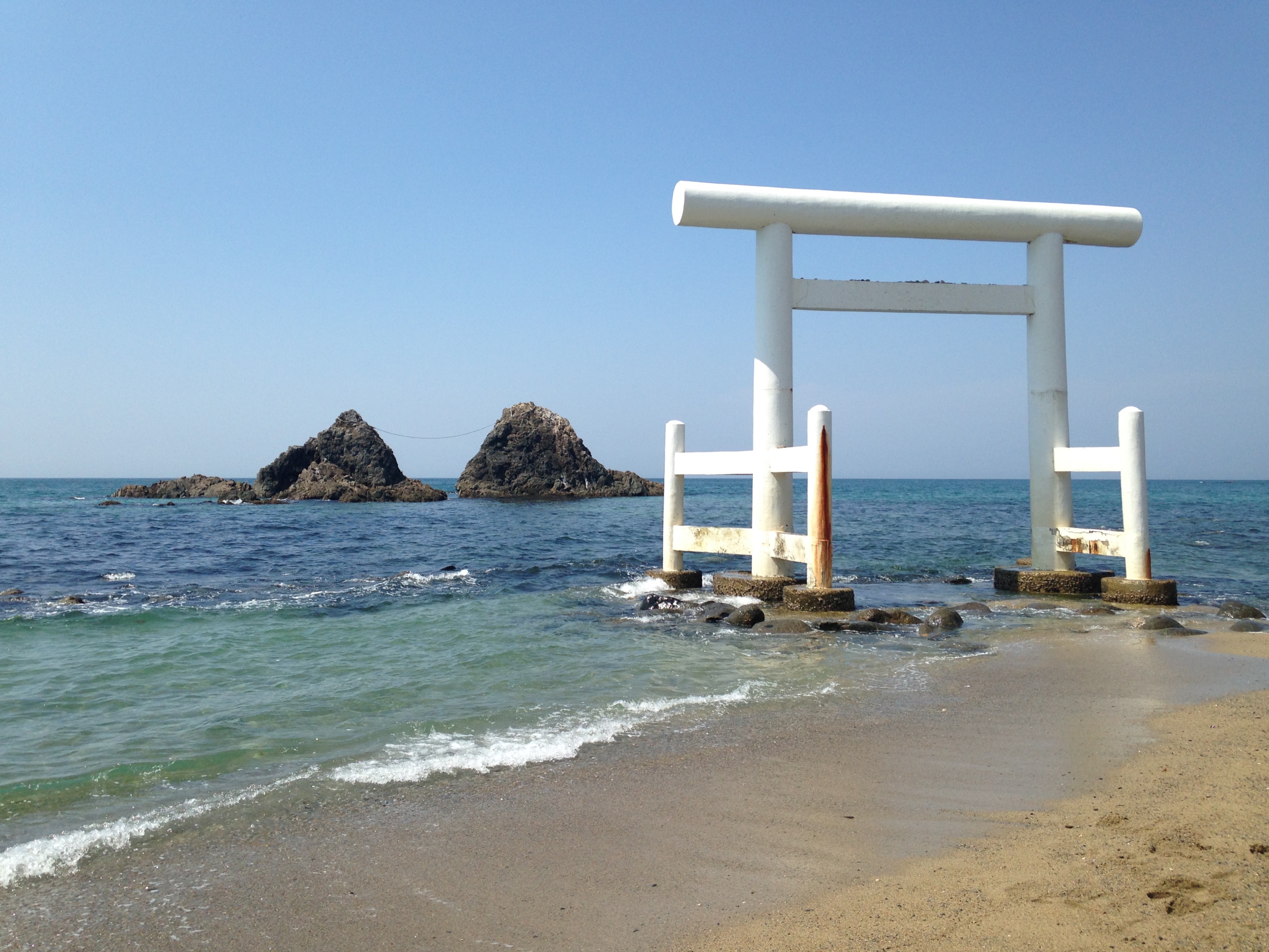 The iconic Meoto Iwa (Wedded Rocks) at Sakurai Futamigaura with the white torii gate. Source: Wikimedia Commons
The route's most iconic landmark featuring two rocky outcrops connected by sacred rope (shimenawa), framed by massive white torii gate standing in surf. Selected as one of "Japan's 100 Best Beaches" and "Japan's 100 Best Sunsets." Rocks represent union of creator kami Izanagi and Izanami according to Shinto beliefs. 🔗 🔗
- Best Timing: Summer solstice for sun setting between rocks; November offers beautiful golden-light autumn sunsets
- Access: Free parking (locked at night)
- Nearby: Multiple beachside cafes including Beach Cafe SUNSET
2. Keya no Oto (Keya Cave)
National Natural Monument and Japan's largest basalt cave at northwestern tip. Cave measures 64 meters high, 90 meters deep, 10 meters wide with hexagonal and octagonal basalt columns arranged in scale-like patterns. 🔗
- Boat Tours: ¥800 adults, ¥400 children; operates 9:30am-4:30pm daily (April-November, weather dependent)
- Access: Large parking lot at Keya no Oto Park; 80 spaces at Keya Beach
- Associated: Totoro Forest - wind-sculpted trees resembling Studio Ghibli forest; 10-min walk from parking
3. Mount Tateishi (210m)
Small mountain offering 360-degree panoramic views of Genkai Sea coastline and Keya Beach. 🔗
- Access: 30-60 min hike from Keya Beach trailhead OR drive to telecommunications tower parking (10-25 min walk to summit)
- Difficulty: Easy, suitable for beginners
- Parking: Small area at upper mountain road; 80 spaces at Keya Beach trailhead
4. Yashi no Ki Buranko (Palm Tree Swing)
Instagram-famous giant swing suspended between palm trees on beach, about 15 minutes east from Meotoiwa. Located on grounds of Katsugyo Chaya Zauo Honten seafood restaurant. 🔗
5. Shiraito Falls
24-meter-high waterfall located 900 meters above sea level on Haganeyama Mountain. Inland from coastal route but accessible by short detour (about 1 hour from Hakata Station by car). 🔗
- Access: Mountain roads are steep and narrow - drive carefully
- Parking: Free; small lot can fill quickly
- Trail: Several minutes walk from parking
- November: Autumn foliage, beautiful seasonal colors
6. Beach Access Points
- Keya Beach: Clean waters, white sand, listed among Japan's top 100 swimming beaches
- Nogita Beach: Sunset ranked in top 100; several well-known cafes
- Fukae Beach: Eastern peninsula location
November Visiting Advantages
Seasonal Benefits
- Peak Photography: Autumn sun angle creates warm coastal lighting
- Comfortable Weather: Pleasant temperatures, no summer heat
- Reduced Crowds: Post-summer low season
- Clear Visibility: Autumn atmospheric clarity
- Keya Boat Tours: Still operating (final month of season)
- Oyster Season: Kakigoya opening for winter season
- Autumn Foliage: Shiraito Falls displays seasonal colors
November Timing
- Sunset: Approximately 5:15-5:30 PM early November
- Golden Hour: 45-60 minutes before sunset
- Strategy: Arrive at western viewpoints (Futamigaura, Keya) by 4:30 PM
- Earlier Darkness: Less daylight means prioritizing key stops
Practical Visiting Tips
Photography Strategy
- Sunrise Locations: Eastern beaches and viewpoints
- Sunset Locations: Sakurai Futamigaura, Keya no Oto area, Nogita Beach
- Best Light: Golden hour 45-60 min before sunset
- Iconic Shots: White torii at Futamigaura, Meoto Iwa rocks, coastal curves
- Equipment: Wide-angle for coastal vistas, telephoto for details, tripod for sunsets
Driving Strategy
- Route Direction: Choose based on sunset timing—counterclockwise to arrive at western viewpoints during golden hour
- Stopping Frequency: Budget for frequent stops—changing views make it tempting to pull over repeatedly
- Time Allocation: Minimum 4 hours for Route 54 with major stops; 6-8 hours for leisurely exploration
- Traffic: Weekday driving offers lighter traffic
- Fuel: Fill tank in Itoshima city center before coastal sections
Crowd Avoidance
- Best Timing: Weekday visits significantly less crowded
- November Advantage: Post-summer low season means fewer crowds overall
- Sunrise Alternative: Early morning drives offer empty roads
- Off-peak Lunch: Cafes during 2-4 PM less busy
November Preparation
- Clothing: Light jacket for coastal wind, layers recommended
- Sun Protection: UV reflection from water significant even in autumn
- Wind: Coastal areas breezy; secure loose items
- Backup Plan: If weather poor, shift to inland attractions (Shiraito Falls, cafes)
Safety Notes
- Road Conditions: Winding coastal roads—drive cautiously on curves
- Weather Dependency: Keya boat tours cancel in rough seas—verify operation before traveling
- Swimming: November water too cold
- Mountain Roads: Shiraito Falls access roads steep and narrow
- Sunset Timing: Futamigaura parking lot locks at night—leave before closure
Integration with Itinerary
Connection to Accommodation
The coastal drive complements stay at Itoshima Retreat House (Nijofukae area):
- Easy access to both eastern and western Route 54 sections
- Sunset viewing without long return drive
- Early morning sunrise photography on eastern beaches
- Two-day exploration: eastern route Day 1, western route Day 2
Multi-Day Strategy
- Day 1 (Nov 1): Eastern peninsula and Shiraito Falls (morning/midday), Sakurai Futamigaura for sunset
- Day 2 (Nov 2): Western peninsula including Keya no Oto boat tour (morning), Mt. Tateishi hike, Keya Beach, coastal drive for afternoon golden hour
Regional Extension
The Itoshima coastal drive connects to broader Genkai Sea Scenic Byway (178 km total extending through Karatsu and Saga Prefecture), enabling extension to Karatsu historic castle town and Saga Peninsula.
Important Notes
Critical Considerations for November 1-2
Keya no Oto Boat Tour: November is final operational month (April-November). Weather can cancel tours even on clear days. Visit early (November 1 morning) to allow backup day if canceled. Call ahead same day to verify operation. 🔗
Sunset Timing: With sunset around 5:15-5:30 PM, daylight is limited. Plan route to arrive at western viewpoints by 4:30 PM for golden hour. Earlier days mean less time for full peninsula exploration—prioritize key stops. 🔗
Parking Closures: Futamigaura parking lot locks at night. Exit before darkness to avoid being locked in. 🔗
Limited Facilities: Gas stations sparse along coastal Route 54. Public restrooms only at three locations. Plan accordingly. 🔗
Location: View on Google Maps
Source: attractions/itoshima/genkai-sea-scenic-drive.md