
About
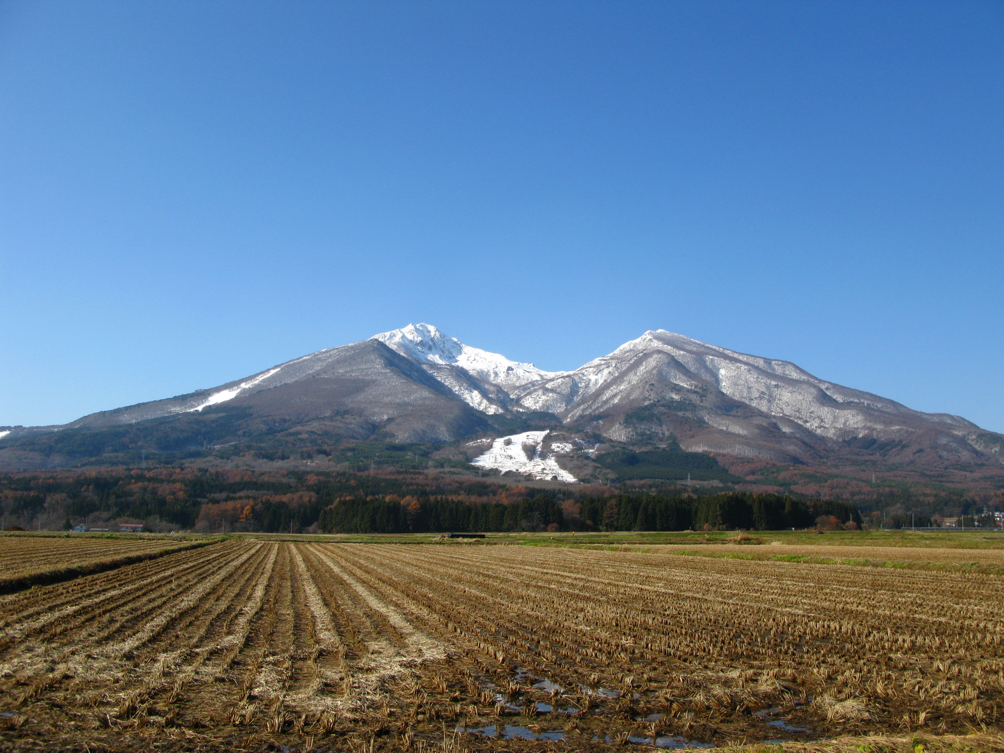 Mount Bandai rising above rice fields in Fukushima Prefecture, showing the mountain's distinctive conical profile when viewed from the south (Omote-bandai). Source: Wikimedia Commons
Mount Bandai (磐梯山, Bandai-san) stands 1,816 meters high in Fukushima Prefecture, serving as the geographic and cultural heart of Bandai-Asahi National Park. This stratovolcano presents two dramatically different faces: from the south (Omote-bandai), it displays a beautiful conical shape known as "Aizu Fuji," while from the north (Urabandai), it reveals a wild, shattered profile—the dramatic scar of its catastrophic 1888 collapse. 🔗
The 1888 Eruption and Its Legacy
On July 15, 1888, Mount Bandai erupted in one of Japan's most devastating volcanic events. At 7:45 AM, after violent earthquakes shook the ground, the Ko-Bandai peak collapsed in a massive phreatic explosion—a volcanic eruption caused by groundwater interacting with hot volcanic rocks rather than molten magma. This collapse unleashed a debris avalanche towering 75 meters high that surged northward at 80 kilometers per hour, spreading across 34 square kilometers and extending 15 kilometers from Mount Bandai. 🔗
The avalanche obliterated three entire hamlets, killing 477 people—the highest volcanic disaster casualty count in modern Japanese history. The massive debris flow dammed several rivers, creating Lakes Hibara, Onogawa, Akimoto, and the iconic Goshikinuma (Five-Colored Ponds) crater lakes. What had been orderly farmland transformed overnight into a boulder-strewn wasteland that would, over time, evolve into one of Tohoku's most scenic highland areas. 🔗
Volcanic Significance
This eruption became a watershed moment for modern Japan. Japanese geologists Seikei Sekiya and Y. Kikuchi visited Bandai within days and published a report considered a classic in volcanology, establishing the "Bandaian-type eruption" classification for large phreatic explosions with voluminous debris avalanches. 🔗
The Meiji government's swift disaster response—including Emperor Meiji's personal donation of 3,000 yen and deployment of the Japanese Red Cross Society in its first peacetime relief mission—signaled Aizu region's full integration into the modernizing nation and established protocols that would shape Japanese disaster management for generations. 🔗
In recognition of this geological and cultural significance, the area surrounding Mount Bandai was designated as a Geopark by the Japanese Geoparks Committee in 2011. The Bandai-san Geopark showcases how volcanic activity created beautiful scenery through repeated rock avalanches, transforming catastrophe into one of Japan's most distinctive landscapes. 🔗
Visiting Information
Getting There from Aizuwakamatsu
By Public Transportation:
- Take JR Ban-etsu West Line to Inawashiro Station (30 minutes from Aizuwakamatsu)
- From Inawashiro Station: Buses to Urabandai region (one bus every 1-2 hours)
- Taxi to Happodai trailhead: Approximately 10,000 yen one way 🔗
By Car (Recommended): Car rental outlets available in Aizuwakamatsu. The scenic Bandaisan Gold Line is a toll-free winding road connecting Bandaimachi Town with Urabandai, ascending the southwestern side of Mount Bandai. 🔗
IMPORTANT: The Bandaisan Gold Line is closed mid-November to mid-April due to heavy snowfall. There is no public transportation along this scenic mountain road, making rental cars essential for flexibility during the open season. 🔗
Key Facilities
Urabandai Visitor Center (Primary Information Hub)
- Hours:
- Summer (April 1 - November 31): 9:00 AM - 5:00 PM
- Winter (December 1 - March 31): 9:00 AM - 4:00 PM
- Closed: Tuesdays (except national holidays)
- Services: Personalized mountain climbing and trekking course advice, bear bell and boot rentals, craft workshops, four-season video presentation
- Contact: 0241-32-2850
- Admission: Free 🔗
Mount Bandai Eruption Memorial Museum
- Hours:
- April-November: 8:00 AM - 5:00 PM
- December-March: 9:00 AM - 4:00 PM
- Admission ends 30 minutes before closing
- Closed: No closing days
- Admission: ¥600 (¥1,100 combined ticket with Mount Bandai 3D World)
- Location: 1093-36 Kengamine, Hibara, Kitashiobara
- Content: Comprehensive documentation of the 1888 eruption and area transformation 🔗
Hiking Season: Late April to early November (safest season, snow-free) 🔗
Best Time to Visit: Late October for peak autumn foliage along the Bandaisan Gold Line 🔗
Current Volcanic Status: Normal/dormant with continuous monitoring. Last documented volcanic tremor was June 25, 2012 (45 seconds duration), with no eruption following. The last magmatic eruption occurred over 25,000 years ago. 🔗
What to See and Do
Educational Facilities
Urabandai Visitor Center This facility presents Bandai-Asahi National Park's natural environment through ecosystem-based exhibits including waterfront sections on the 300+ lakes and ponds of Urabandai, forest transformation displays, and a plains section with a diorama showing how the 1888 eruption changed the land. Staff provide personalized hiking and trekking advice, making this an ideal first stop before outdoor adventures. The center hosts craft workshops and events, with materials for creating animal paintings and pin badges. 🔗
Mount Bandai Eruption Memorial Museum & Hibara Historical Museum These facilities document the comprehensive history of the 1888 eruption, the area's geological transformation, and community recovery. The Eruption Memorial Museum presents artifacts, photographs (including the first news photograph printed by Yomiuri Shimbun), and interpretive displays explaining the phreatic explosion mechanism and debris avalanche that reshaped the landscape. 🔗
Viewing Points
Southern Perspective (Omote-bandai) From Inawashiro town, Mount Bandai displays its beautiful conical "Aizu Fuji" profile, particularly photogenic when rising above soba noodle flower fields and with Lake Inawashiro's vast waters in the foreground. Japan's fourth-largest lake provides excellent viewing opportunities from its shores. 🔗
Summit Views (Advanced Hikers) The summit offers 360-degree panoramas encompassing Lake Inawashiro, the Azuma Peak Range, Adatara Peak Range, Iide Peak Range, Nasu Peak Range, and Hiuchigatake in the Oze Mountains. The Happodai route (summer only) is the shortest course, starting at 1,194 meters elevation halfway along the Bandaisan Gold Line. The Ojima Trailhead route's second half offers unobstructed views of the Aizu Basin and distant Iide mountains. 🔗
Bandaisan Gold Line This scenic toll-free mountain road provides panoramic views over the highlands and passes the scenic Nakatsugawa Gorge, offering accessible viewing for non-hikers. Late October transforms the slopes into brilliant orange and yellow autumn foliage. 🔗
Seasonal Considerations for October-November Visits
October (Oct 21-23) Visits:
- Optimal Access: Full access to all routes, trails, and the Bandaisan Gold Line
- Autumn Colors: Late October offers peak foliage along mountain roads
- Weather: Generally stable hiking conditions, though prepare for mountain weather variability
- Facilities: All visitor centers and museums operating on summer schedules (longer hours)
November (Nov 9-18) Visits:
- ACCESS LIMITATION: Bandaisan Gold Line typically closes mid-November due to snowfall
- Reduced Options: Limited to valley-level facilities and lower elevation viewing points
- Weather: Transition to winter conditions, increased snow risk at higher elevations
- Hiking: Not recommended due to snow and trail closures
- Focus Shift: Emphasis on educational facilities (museums, visitor centers) and Lake Inawashiro viewpoints rather than mountain access
Practical Visiting Tips
Planning Strategy
For October Visits:
- Start at Urabandai Visitor Center for personalized route advice
- Drive the Bandaisan Gold Line for scenic overlooks and access to Goshikinuma trailheads
- Visit Mount Bandai Eruption Memorial Museum for geological context
- Explore Lake Inawashiro shores for southern mountain views
- Consider the combined ticket (¥1,100) for both museum and 3D World
For November Visits:
- Confirm Bandaisan Gold Line status before planning (expect mid-November closure)
- Focus on valley-level attractions: museums, visitor centers, Lake Inawashiro
- Prepare for winter transition conditions with appropriate clothing
- Adjust expectations from mountain access to cultural/educational focus
Visitor Centers and Services
- Arrive Early: Visitor centers open at 9 AM; arrive early for personalized hiking advice
- Bear Precautions: Rent bear bells from Urabandai Visitor Center (essential for forest trails)
- Boot Rentals: Available at visitor center for impromptu hiking
- Museum Timing: Allow 1-1.5 hours at Eruption Memorial Museum; admission ends 30 minutes before closing
Photography
Best views of Mount Bandai from Lake Inawashiro are typically in morning light, when the mountain is front-lit. The Urabandai side offers dramatic collapsed-peak perspectives showing the volcanic scar. Autumn foliage photography along the Bandaisan Gold Line is spectacular in late October with diffused light conditions.
Regional Context and Connections
Understanding Mount Bandai's 1888 eruption and its ongoing volcanic monitoring provides essential context for appreciating:
- Goshikinuma: Direct creation from eruption debris damming rivers
- Lake Inawashiro: Volcanic influence on water chemistry and landscape
- Urabandai Landscape: Transformation from farmland to boulder-strewn wilderness to scenic highland
This site represents modern Japan's first major volcanic disaster response, marking significant advances in:
- Scientific volcanology and eruption classification
- Government disaster relief protocols
- Community recovery and resilience
- Volcanic monitoring and public safety systems
Nearby Attractions
Within Urabandai Region:
- Goshikinuma (Five-Colored Ponds): 3-4 km nature trail through crater lakes created by 1888 eruption
- Lake Hibara: Largest of the dammed lakes, water sports and recreation
- Lake Onogawa and Lake Akimoto: Additional eruption-created lakes
Inawashiro Area:
- Lake Inawashiro: Japan's fourth-largest lake with mountain views
- Aizu Bandai-san Ropeway: Aerial views of the volcanic landscape
Extended Regional Connections:
- Aizuwakamatsu: Historical samurai city (1 hour)
- Kitashiobara: Highland resort area with additional volcanic features
Integration with Other Locations
Mount Bandai serves as the geological and geographic anchor connecting multiple Aizuwakamatsu extended day trip destinations:
Direct Geological Connections:
- Goshikinuma Trail: Eruption-created crater lakes within the debris avalanche zone
- Lake Inawashiro: Volcanic influence and southern mountain viewpoints
- Urabandai Highland: Entire landscape transformed by 1888 collapse
Access Route Planning: All destinations (Mount Bandai, Goshikinuma, Lake Inawashiro) are accessible via the Bandaisan Gold Line and Urabandai road network, making a comprehensive day trip circuit feasible from Aizuwakamatsu. The Visitor Center at Urabandai serves as the central orientation point for the entire region.
Sequential Understanding:
- Mount Bandai context (this research): Geological history and eruption mechanics
- Goshikinuma experience: Direct observation of eruption-created landscape features
- Lake Inawashiro perspective: Broader regional impact and southern mountain views
Important Notes
Critical Planning Considerations
Seasonal Access Restrictions:
- The Bandaisan Gold Line closes mid-November to mid-April—this fundamentally changes trip planning for November visits
- Hiking season ends early November; mountain trails become snow-covered and dangerous
- Public transportation along mountain roads is non-existent; car rental essential during open season
Volcanic Monitoring:
- Mount Bandai maintains "normal/dormant" status with continuous seismic monitoring
- No eruption risk for visitors under normal conditions
- Monitoring systems in place since the 2000 seismic swarm (416 earthquakes in one day, no eruption followed)
- Last significant volcanic tremor: June 25, 2012 (45 seconds, no eruption) 🔗
Visit Duration Context: This is regional context research rather than a specific single-stop attraction. Understanding Mount Bandai's geological history and eruption legacy enhances appreciation of Goshikinuma, Lake Inawashiro, and the entire Urabandai landscape transformation—all accessible as part of a comprehensive extended day trip from Aizuwakamatsu.
Educational Value: The combination of Urabandai Visitor Center, Mount Bandai Eruption Memorial Museum, and on-site observation of eruption-created features (Goshikinuma, dammed lakes) provides exceptional understanding of volcanic processes and disaster-to-recovery transformation unique in Japan's volcanic landscape.
Location: View on Google Maps
Source: attractions/aizuwakamatsu/mount-bandai-regional-context.md