
About
 Kappa Bridge spanning the Azusa River with the Hotaka Mountain Range backdrop - the iconic view of Kamikochi (Source: Wikimedia Commons) 🔗
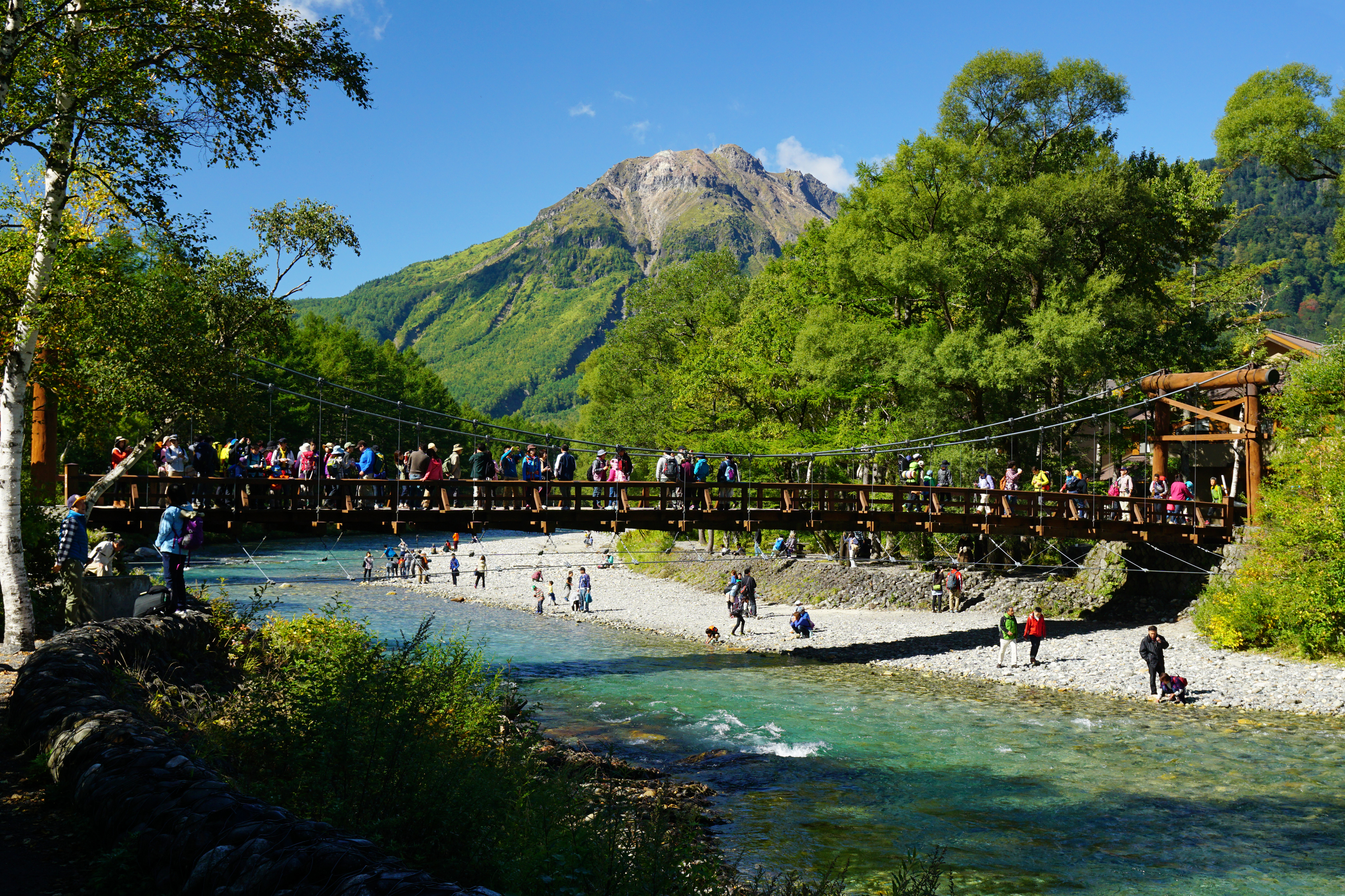
Kamikochi is a remote mountainous highland valley within the Hida Mountains range in western Nagano Prefecture, Japan. The Azusa River, the headwater of Japan's longest river (the Shinano River), flows through the length of the valley, creating a stunning scenic corridor flanked by the Northern Japanese Alps. 🔗
The valley was formed when Mount Yakedake erupted in 1915, damming the Azusa River and creating the iconic Taisho Pond. This pristine alpine valley sits at approximately 1,500 meters elevation and has been protected as part of Chūbu-Sangaku National Park, maintaining its natural state with minimal development. The Azusa River features startling blue glacial water perfect for mountain photography, flanked by some of Japan's highest peaks including the Hotaka Mountain Range and the active volcano Mount Yakedake. 🔗
Kamikochi is designated as one of Japan's National Cultural Assets on the list of Special Natural Monuments and Special Places of Scenic Beauty, representing where "nature and culture flow as one." 🔗
Cultural & Historical Significance
The Azusa River valley holds deep cultural significance in Japanese mountain worship traditions (Sangaku Shinkō). The valley's pristine natural state and protection as a UNESCO heritage component reflect Japan's reverence for sacred mountain landscapes. The name "Kamikochi" itself contains the character for "god" (神), emphasizing the spiritual importance of this alpine sanctuary.
Kamikochi has only been moderately developed, with half a dozen hotels, a few souvenir shops, mountain huts, and well-maintained hiking trails along both sides of the river. This careful balance between accessibility and preservation demonstrates Japanese environmental stewardship principles. The valley represents a gateway to the Northern Alps' sacred peaks, including Mount Hotaka, one of Japan's 100 Famous Mountains (Hyakumeizan). 🔗
The Taisho Pond's formation in 1915 created a landscape feature that has become iconic in Japanese alpine imagery—dead trees reflected on the mirror-like surface create a haunting aesthetic that represents both natural power and ephemeral beauty.
Visiting Information
Access:
- Critical: Private cars and motorcycles NOT allowed in Kamikochi year-round due to strict national park traffic regulations
- Must park at Hirayu Parking Area (Akandana) and transfer to shuttle buses
- From Takayama: Take Route 158 to Hirayu Parking Area, approximately 47 km (~44 minutes drive)
- Parking: Hirayu Akandana Parking - three municipal car parks (850 cars total), ¥600 per day
- Peak season warning: Autumn foliage weekends may be full by 5-6 AM; arrive early or visit weekdays 🔗
Route Context:
- Distance from main Fujikawaguchiko-Takayama route: Significant detour (~45 min from Takayama)
- Drive to Hirayu parking: ~45 minutes from Takayama
- Shuttle bus: 30 minutes
- Total access time: 1.5 hours each way (minimum)
- Full detour commitment: 3+ hours for access alone 🔗
Shuttle Bus:
- From Hirayu Parking to Kamikochi Bus Terminal: 25-30 minutes
- Cost: ¥1,500 one way, ¥2,800 round trip
- Frequency through October 31: Every 30 minutes
- Frequency November 1-15: Every 60 minutes
- Non-reserved buses - purchase tickets on day of travel
- Operating hours: 5:00 AM - 7:00 PM (no buses 7:00 PM - 5:00 AM)
- Starting FY2025: Buses require online or counter reservations (no phone reservations) 🔗
Hours:
- Operating Season: April 17 - November 15 annually (closed November 16 - April 16)
- 2025 Closure Date: November 15, 2025 (all facilities close for winter)
- Visitor Center Hours: 8:00 AM - 5:00 PM daily during season
- October 24 Status: Open and accessible (within operating season) 🔗
Seasonal Considerations:
- October 24, 2025: Peak autumn foliage season (mid-October optimal)
- October = peak season with very high visitor numbers
- Weekday timing helps but still expect crowds
- Main trails can feel overcrowded during peak foliage
- Temperatures: 7-18°C (morning frost possible, dress in layers)
- Light snow possible after mid-October 🔗
The Experience
Kappa Bridge (Kappabashi): The 36.6-meter wooden suspension bridge spanning the Azusa River is the most photographed spot in Kamikochi. Views upstream reveal the Hotaka Mountain Range and Mount Myojindake; views downstream show the active volcano Mount Yakedake with its smoking crater. Located 5 minutes from the bus terminal, the bridge serves as the heart of Kamikochi's visitor experience. 🔗
Taisho Pond: Formed in 1915 when Mount Yakedake eruption dammed the Azusa River, this pond is famous as a "water mirror" with crystal-clear reflections of the Hotaka Range. Dead trees reflected on the surface create haunting aesthetics. Best experienced in early morning for mist effects and mirror-like surface. Peak foliage in late October. Walking time: 25 minutes from Kappa Bridge. 🔗
Myojin Pond: Sacred pond with admission fee (¥500), featuring reflections of Myojin Peak and autumn foliage. Peak foliage in mid to late October. Walking time: 1 hour from Kappa Bridge. 🔗
Azusa River Trail System:
- Mostly flat terrain requiring no hiking experience
- Well-maintained trails flank both sides of river
- "Ugan" (left/upstream side from Kappa Bridge) has more viewpoints
- Excellent signage throughout the valley
- Striking blue glacial water with mountain reflections 🔗
Recommended Half-Day Route (4 hours): Bus Terminal → Kappa Bridge → Visitor Center → Myojin Bridge → Myojin Pond → Kappa Bridge → Weston Monument → Tashiro Bridge → Nature Trail → Taisho Pond → Bus Terminal 🔗
Practical Visiting Tips
Driving Considerations:
- Cannot drive into Kamikochi - mandatory shuttle bus system
- Park at Hirayu Akandana (arrive early on weekends)
- Budget ¥600 parking + ¥2,800 round-trip bus = ¥3,400 minimum
- Full-day commitment: 7-8+ hours from main route (access + visit)
- Consider whether time budget allows this significant detour
Route Integration:
- Major detour (30+ minutes off route) requiring full day commitment
- Best integrated with overnight stay or dedicated day trip from Takayama
- If visiting Kamikochi: Plan as primary activity for the day
- Alternative: Skip if time-constrained; prioritize other route stops
- October 24 (weekday) provides crowd advantage over weekends 🔗
Cultural Etiquette & Park Rules:
- No taking: Plants, insects, living organisms protected by law
- No feeding: Wild animals (disrupts ecosystem)
- No littering: Take all trash home (bring trash home policy)
- No bringing in: Pets or non-native species prohibited
- No trespassing: Stay on designated paths only
- No bicycles on trails
- No drones in National Park
- Use bear bells while hiking 🔗
Budget Considerations:
- General admission: Free (no entrance fee to Kamikochi)
- Shuttle bus: ¥2,800 round trip
- Parking: ¥600 per day
- Myojin Pond: ¥500 admission
- Public toilets: ¥100 fee (no change provided)
- Total minimum: ¥3,400 + ¥100 toilets
- Day-trippers can use hotel facilities (hot spring baths, shops in lobbies) 🔗
Crowd Avoidance:
- Visit on weekdays rather than weekends/holidays
- Arrive before 6 AM for mist effects and empty trails
- Early November alternative: Nov 1-5 offers good weather, autumn leaves, fewer crowds
- Explore quieter spots: Konashidaira Camping Area, Dakesawa Marsh less crowded 🔗
Photography:
- Early morning for mystical mist and reflections
- Shoot before approaching bridges for integrated landscape views
- Use Ugan (left) trail for more viewpoints
- Don't throw rocks in water (ruins reflections for others)
- Taisho Pond dawn: Mirror-like surface before wind picks up 🔗
Safety & Practical:
- No cell phone service in Kamikochi
- Print/screenshot reservations before arrival
- Bring sufficient cash (limited card payment)
- Layered clothing for temperature changes (7-18°C range)
- Waterproof hiking shoes essential
- Bear bell recommended
- Weather changes quickly; bring rain gear 🔗
Location: View on Google Maps
Source: attractions/fujikawaguchiko-to-takayama-scenic-route/azusa-river-valley.md