
About
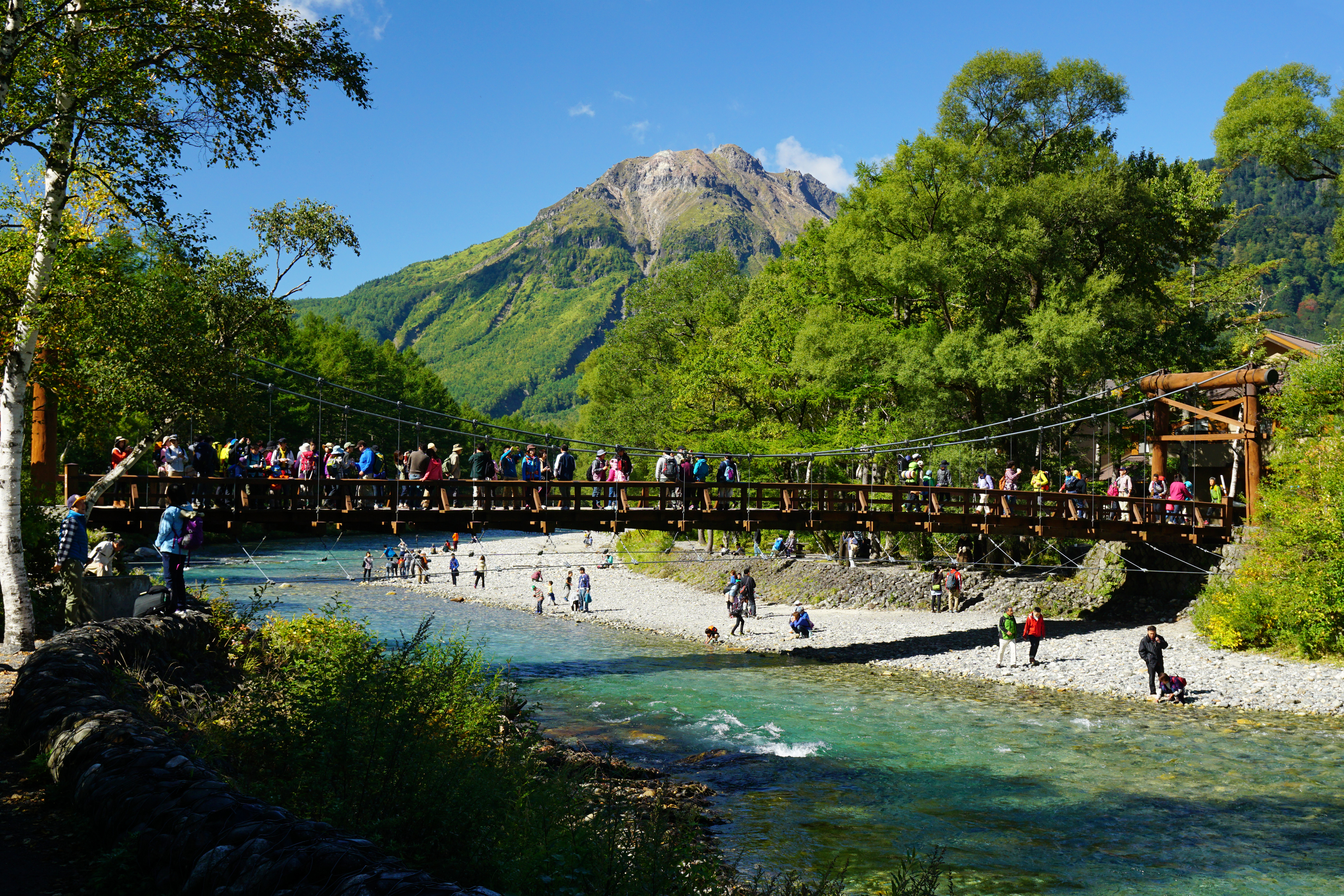 Kappa Bridge with the dramatic Hotaka Mountain Range backdrop - the iconic viewpoint of Kamikochi Alpine Valley. Source: Wikimedia Commons
Kamikochi is a pristine 15-kilometer-long plateau along the Azusa River, nestled at approximately 1,500 meters above sea level in the heart of the Northern Japan Alps. Often called the "Japanese Yosemite Valley," this remote mountainous highland valley represents one of Japan's most significant conservation achievements. The valley received the rare dual designation as both a National Special Place of Scenic Beauty and Special Natural Monument in 1952, recognizing its alpine flora, glacial landforms, and dramatic Hotaka skyline. 🔗
Cultural & Religious Significance
Once revered as the sacred realm of "Kami-gōchi" ("within the divine enclosure"), Kamikochi still retains a strong atmosphere of nature worship centered on the Okumiya of Hotaka Shrine. The valley showcases ancient glacial valleys intertwined with wetlands born of volcanic activity, bordered by Mount Hotaka to the north and the active volcano Mount Yake to the south, with surrounding peaks reaching 3,190 meters. 🔗
The area represents Japan's conservation philosophy and the spiritual connection between nature and Japanese culture, with strict protection measures that include complete prohibition of private vehicles since 1994. 🔗
Visiting Information
Transportation from Takayama (Total Journey Time: 90 minutes):
-
Takayama to Hirayu Onsen: Nohi Bus departing hourly from Takayama Bus Center (Stop 5)
- Duration: 60 minutes, Cost: 1,600 yen one-way
-
Hirayu Onsen to Kamikochi: Shuttle bus (required transfer)
- Departures: 20 and 50 minutes past each hour
- Duration: 25 minutes, Cost: 1,500 yen one-way, 2,800 yen round-trip (valid 7 days)
Total Cost: 3,000 yen one-way, 5,800 yen round-trip for adults
CRITICAL ACCESS INFO: Open mid-April to November 15 (CLOSES November 16 for winter). Private vehicles prohibited beyond Kama Tunnel. 🔗
Route-Specific Access (Scenic Route via Kiso Valley)
From Kiso Valley Route 19 (Scenic Route):
- Continue northbound on Route 19 through Kiso Valley post towns
- At Kiso Fukushima, take Route 361 westbound toward Matsumoto/Kamikochi
- Follow Route 361 through mountain passes (~35 km, 50 min - 1 hour 10 min)
- Merge onto Route 158 westbound at Matsumoto area
- Continue on Route 158 mountain section approximately 45 km to Hirayu Akandana Parking (45 min - 1 hour 10 min)
Alternative Access from Southern Kiso Valley:
- From Narai-juku or Magome/Tsumago: Continue on Route 19 north to Kiso Fukushima, then Route 361
- Total distance from mid-Kiso Valley: 80-90 km via Route 361 + Route 158
- Total driving time: 1.5-2 hours to Hirayu Parking
Total Detour Impact: 2-3 hours driving + shuttle time + valley exploration time
Parking Options for Scenic Route Travelers:
Option 1: Hirayu Akandana Parking (RECOMMENDED)
- Location: Okuhida Onsengo Hirayu, Takayama, Gifu 506-1433
- Distance from Kiso Fukushima via Route 361: ~80 km (1.5-2 hours)
- Capacity: ~850 vehicles
- Cost: ¥600/day (regular cars)
- Shuttle: Nohi Bus, 25-30 minutes to Kamikochi, buses depart at :20 and :50 past each hour
- Round-trip Shuttle: ¥2,800 adults (valid 7 days)
- Advantage: Buses START at Hirayu, guaranteeing seats; positioned on route continuation toward Takayama
Option 2: Sawando Parking (Matsumoto Side Alternative)
- Location: 4161-2 Azumi, Matsumoto, Nagano 390-1520
- Distance from Route 361/158 junction: ~33 km (32-45 minutes)
- Cost: ¥700/day
- Shuttle: Alpico Transportation, 30 minutes
- Disadvantage: Buses continue from earlier stops, may already be full during peak season; adds backtracking for Takayama continuation
Recommended Choice: Hirayu Akandana Parking for better route flow and guaranteed shuttle seating.
Detour Classification: MAJOR DETOUR (30+ minutes, significant attraction)
- Detour driving time: 2-3 hours from Kiso Valley route continuation
- Shuttle time: 50-60 minutes round-trip including waiting
- Minimum valley time: 2-3 hours for basic trails
- Total time commitment: 5-7 hours minimum
The Experience
Core Valley Experience (Easy Walking Routes): Kappa Bridge Circuit (3-4 hours) features the iconic 36.6m suspension bridge offering spectacular views of Hotaka peaks and Mount Myojindake upriver, Mount Yakedake downriver. Taisho Pond provides mirror-like reflections of Hotaka peaks (2.5-hour round trip from Kappa Bridge). Myojin Pond at Hotaka Shrine Okumiya offers sacred pond access (1 hour walk from Kappa Bridge, 300 yen admission). 🔗
Challenging Day Hikes (For Experienced Hikers): Dakesawa Valley Trail offers 2.5 hours climb to viewing platform with dramatic Hotaka Range views. Karasawa Cirque provides spectacular autumn foliage amphitheater (October peak colors). 🔗
Wildlife Observation: Japanese Macaques year-round residents commonly seen on Myojin trails, rock ptarmigan (rare but lucky sightings), mandarin ducks, red-flanked bluetail, and Japanese Serow (mountain goat-like protected species). Feeding Wildlife Strictly Prohibited
Practical Visiting Tips
Optimal Timing for Late October 2025:
- Peak Autumn Foliage: Mid-October (perfect timing for October 24-26 visit)
- Featured Colors: Yellow white-birch trees, orange and red elm foliage
- Weather: Can drop below freezing, especially at night and early morning
- Recommended Gear: Winter clothing essential from mid-October onward 🔗
Photography and Strategy:
- Best Photo Spots: Kappa Bridge facing upriver (Hotaka peaks), Taisho Pond reflections
- Optimal Lighting: Early morning and late afternoon for mountain views
- Crowd Management: Purchase full round-trip tickets at parking area (cheaper than individual segments)
- Return Planning: Obtain numbered boarding tickets (seiriken) immediately upon arrival at Kamikochi 🔗
Conservation Restrictions:
- No pets allowed in National Park Special Protection Zone
- No bicycles on trails
- No unauthorized camping outside designated areas
- No drones permitted in National Park Special Protection Zone
- Vehicle restrictions strictly enforced
Weather Contingency: Mountain weather changes rapidly; monitor forecasts. Below-freezing temperatures possible from mid-October. Clear days offer spectacular alpine views; cloudy conditions still beautiful for forest walks.
Route Integration Recommendations (Scenic Route Context)
Primary Recommendation: Save for Takayama Day Trip
Based on scenic route-specific analysis, Kamikochi is better experienced as a day trip from Takayama base rather than en route stop for these reasons:
- Time Allocation: 5-7 hour commitment overwhelms cultural scenic route flow
- Route Character Conflict: Scenic route emphasizes Kiso Valley post towns; Kamikochi requires significant detour from this cultural corridor
- Exploration Quality: Rushed 2-3 hour valley visit doesn't justify detour effort from cultural route
- Route Efficiency: Adds 5-6 hours to already long scenic route day (Fujikawaguchiko to Takayama via Kiso Valley = 4-5 hours base + cultural stops)
- Cultural Continuity: Kiso Valley post towns create cohesive cultural narrative; Kamikochi alpine detour disrupts this flow
Optimal Strategy:
- October 24: Complete Fujikawaguchiko to Takayama scenic route efficiently (6-8 hours with Kiso Valley cultural stops)
- October 25 or 26: Day trip to Kamikochi from Takayama base with full 6-hour exploration
If Visiting En Route (Not Recommended for Scenic Route):
Minimum Requirements:
- Depart Fujikawaguchiko by 5:00 AM (even earlier than main route due to longer scenic route base time)
- Accept skipping most/all Kiso Valley post towns (defeats scenic route purpose)
- Pack light day bag for shuttle, secure luggage in car
- Accept compressed 2-3 hour Kamikochi exploration
- Prepare for 5:00-6:00 PM Takayama arrival
Scenic Route Specific Consideration: Choosing Kamikochi detour means sacrificing Kiso Valley cultural experiences (Narai-juku, Tsumago, Magome post towns). The scenic route's primary value is the post town cultural corridor, not alpine scenery. If Kamikochi is priority, the main expressway route offers more efficient access.
October 24, 2025 Specific Considerations:
- Peak Foliage Season: Late October is prime autumn color season in both Kiso Valley AND Kamikochi
- Crowd Impact: Heaviest crowds of the season at both locations, Friday slightly better than weekend
- Parking Strategy: Arrive before 8:00 AM at Hirayu for best availability (requires 5:00 AM Fujikawaguchiko departure)
- Fuel Planning: Fill up at Kiso Fukushima BEFORE Route 361 detour (limited services on mountain road)
- Cash Requirements: Parking ¥600 cash preferred
Location: View on Google Maps
Source: attractions/fujikawaguchiko-to-takayama-scenic-route/kamikochi-alpine-valley.md