
About
 Tsunoshima Bridge crossing the turquoise Sea of Japan - one of the scenic highlights along the coastal peninsula drives. Photo by Fujitani Yoshihide, CC BY-SA 3.0, via Wikimedia Commons
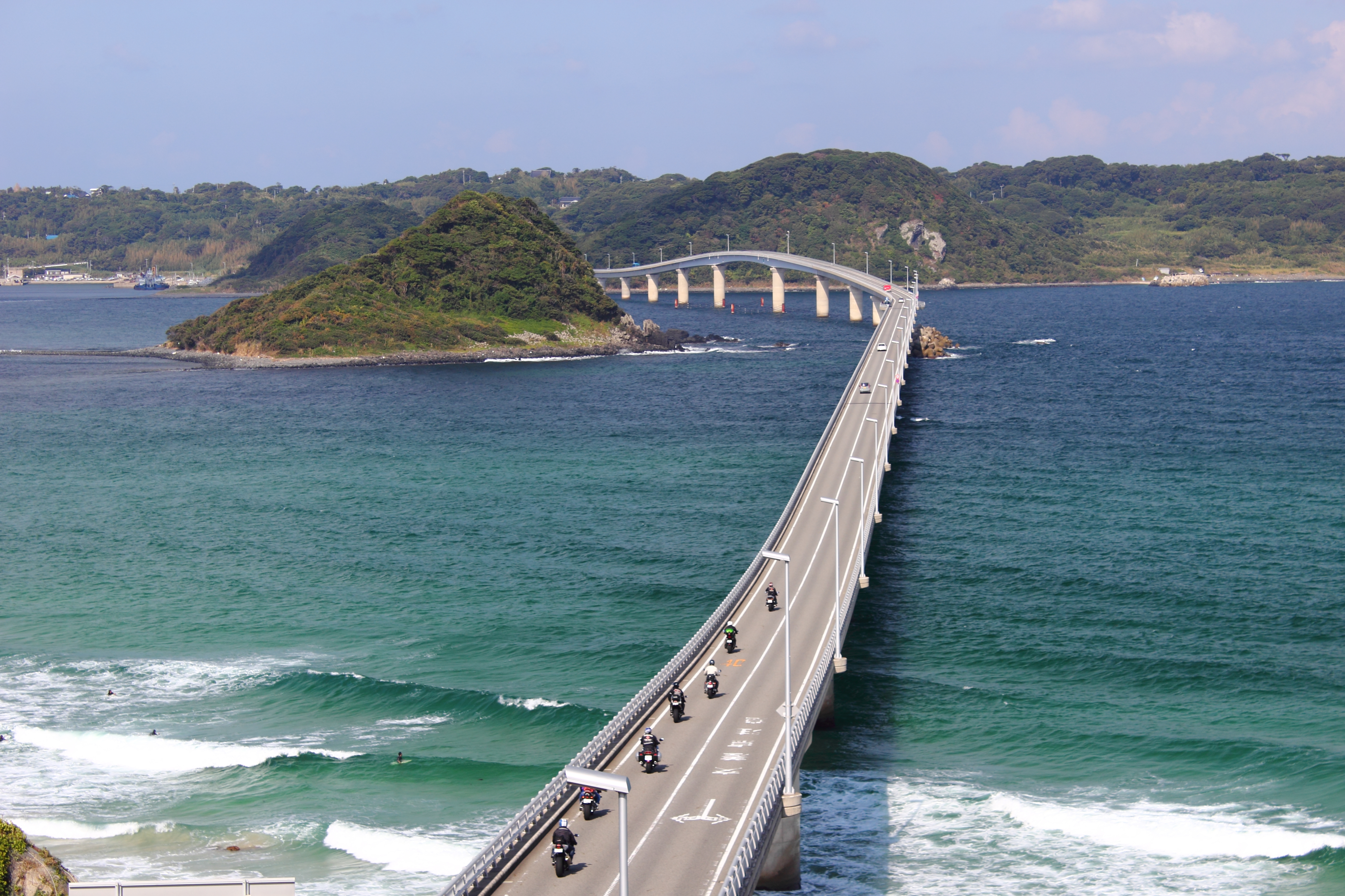
The coastal peninsula drives connecting Tsunoshima Bridge to the Hagi area represent one of Yamaguchi Prefecture's premier scenic driving experiences. This route combines breathtaking Sea of Japan coastal views with access to cultural and natural landmarks, earning recognition as one of Japan's most exhilarating driving courses. 🔗
The drives primarily follow National Route 191, a 284.1 km (176.5 mi) national highway connecting Shimonoseki to Hiroshima, with the Yamaguchi coastal section offering stunning seascapes known as "Nagato Blue." 🔗 The routes connecting the various areas are popular as exhilarating driving courses, showcasing the dramatic intersection of mountains, coastline, and cultural heritage. 🔗
Cultural & Historical Significance
The coastal peninsula drives traverse the Kita-Nagato Kaigan Quasi-National Park, where wind and waves have sculpted remarkable coastal formations including sheer cliffs, sea-carved stone pillars, and tunnel-like rock formations. 🔗 The Sea of Japan's distinctive cobalt blue color - locally called "Nagato Blue" - provides a constant visual companion throughout the drive. 🔗
UNESCO Heritage Connection
The coastal route culminates in Hagi, a UNESCO World Heritage samurai castle town where the sea meets preserved Edo-period architecture. 🔗 This seamless transition from natural beauty to cultural heritage exemplifies Yamaguchi's identity as the "Kyoto of the West."
Architectural Integration
The 1,780-meter Tsunoshima Bridge serves as the route's iconic gateway, its distinctive curved design proceeding straight from the mainland before curving as it passes Hatoshima Island. 🔗 Completed in 2000 and recognized with the Excellence Award by the Japan Society of Civil Engineers for its environmentally-conscious design, the bridge creates a seamless connection between scenic road sections. 🔗
Visiting Information
Access: From Tsunoshima Bridge area (Shimonoseki) northward through Nagato to Hagi via National Route 191 Distance: Approximately 60-70 km between Tsunoshima Bridge and Hagi city center Estimated Drive Time: 1.5-2 hours without stops; 3-4 hours with scenic viewpoint stops Road Conditions: Well-maintained two-lane coastal highway with good signage Hours: Roads open 24 hours; scenic viewpoints accessible anytime Costs: No tolls on Route 191 or Tsunoshima Bridge; some parking areas free, others paid 🔗
Key Sections:
- Tsunoshima Bridge Section: Free parking at Amagase Park on the mainland side before the bridge 🔗
- Nagato Coastal Section: Multiple pullouts along Route 191 with Sea of Japan views
- Omijima Island Access: Bridge-connected from mainland near Nagato; parking lot at island's narrowest point with restaurants and beach access 🔗
- Hagi Approach: Route 191 continues directly into Hagi's coastal areas
Seasonal Considerations for Late October: October brings particularly favorable conditions with clearer skies, making it an ideal time to visit historic sites and enjoy outdoor activities. 🔗 Temperature ranges of 10-17°C provide comfortable driving conditions. The clearer autumn atmosphere enhances visibility of distant coastal features and islands across the Sea of Japan.
The Drive Experience
Driving Characteristics
The coastal peninsula drives offer an engaging yet comfortable driving experience suited to route travelers seeking scenic beauty without challenging road conditions. Route 191 maintains consistent two-lane highway standards with gentle curves that follow the natural coastline, creating what Japanese travel guides describe as "exhilarating driving courses." 🔗
The route is characterized by:
- Moderate speeds: Generally 40-60 km/h through scenic sections, allowing drivers to appreciate views while maintaining safe progress
- Good road surface: Well-maintained asphalt with clear lane markings
- Frequent viewpoint pullouts: Designated parking areas at major scenic spots prevent need for unsafe roadside stopping
- Clear signage: Bilingual signs mark major attractions and viewpoints
Key Viewpoints and Photography Spots
Amagase Park - Tsunoshima Bridge Viewpoint:
- Free parking lot in front of the bridge 🔗
- Postcard-perfect view of the 1,780-meter curved bridge stretching across cobalt blue waters
- Best lighting: Morning to midday for front-lit bridge; late afternoon for dramatic side lighting
- Split into two sections on both ends of the bridge with viewing platforms and amenities 🔗
Tsunoshima Island Circuit:
- Five-minute drive from bridge to lighthouse area
- Yumesakinami Park next to Tsunoshima Lighthouse at the northwestern tip
- Can climb to top of lighthouse (fee applies) for panoramic views of entire island and Sea of Japan 🔗
- Some of the clearest waters in Yamaguchi Prefecture surround the island 🔗
Omijima Island "Marine Alps":
- Parking lot at island's isthmus (narrowest point) next to main road (Route 283) with restaurants and beach access 🔗
- 1,900-meter trekking road with information boards at scenic spots; dramatic views of 40km of cliffside coastline 🔗
- Sheer cliffs, stone pillars, and sea-carved formations earning the "Alps of the Sea" nickname 🔗
- Detour time: 30-45 minutes for viewpoint and short walk; 2+ hours for full nature trail circuit
Route 191 Coastal Viewpoints:
- Multiple pullouts: Designated parking areas along the coastal route with Sea of Japan views
- Roadside Station Kitaura Kaido Hohoku: Perfect view of Waku harbor and Tsunoshima Bridge with local food options 🔗
Weather and Visibility Considerations for October 30
Late October provides some of the year's best conditions for coastal driving in Yamaguchi:
- Clear visibility: 61% clear skies typical for late October, with clearer autumn atmosphere enhancing distant views across the Sea of Japan 🔗
- Comfortable temperatures: 10-17°C range allows for comfortable stops without extreme cold or heat; ocean breezes moderate coastal temperatures
- Autumn colors: Late October marks the beginning of peak autumn foliage (through mid-November), adding warm tones to the predominantly blue coastal palette
- Sea conditions: Generally calm seas in autumn create the ideal cobalt blue water clarity that makes Tsunoshima Bridge famous 🔗
- Photography lighting: Lower autumn sun angle creates more dramatic coastal lighting throughout the day
Practical Visiting Tips
Driving Strategy
Start early: Depart Tsunoshima Bridge area in early morning (7-8 AM) for best light and minimal crowds at Amagase Park viewpoint
Plan strategic stops: The coastal route offers numerous viewpoints; prioritize Amagase Park (Tsunoshima Bridge), one or two Route 191 pullouts with exceptional views, and Omijima Island if time allows
Fuel planning: Fill tank before beginning coastal section; gas stations less frequent along scenic coastal roads
Navigation: Download offline maps; cellular coverage generally good along Route 191 but may be intermittent on Tsunoshima and Omijima islands
Photography Recommendations
Tsunoshima Bridge: Amagase Park provides the iconic viewpoint; arrive early morning or late afternoon for optimal lighting. When sea is calm and weather clear, the transparency around the bridge stands out even more. 🔗
Coastal colors: The distinctive "Nagato Blue" sea color photographs best in clear conditions with low sun angles; autumn's clearer atmosphere enhances color saturation. 🔗
Marine Alps: Omijima's dramatic cliff formations require wide-angle lens; polarizing filter enhances contrast between rock, sea, and sky
Timing for light: October's lower sun angle creates more dramatic coastal lighting throughout the day compared to summer's overhead sun
Cultural Etiquette
Viewpoint courtesy: Popular viewpoints like Amagase Park can be busy; be mindful of other photographers and avoid blocking viewing platforms
Island respect: Tsunoshima and Omijima are inhabited islands; drive respectfully through residential areas and observe posted speed limits
Parking compliance: Use designated parking areas only; coastal road shoulders often narrow with limited safe stopping
Timing and Integration
Allow adequate time: Budget minimum 3-4 hours for the coastal drives with viewpoint stops; 5-6 hours if including Omijima Island nature trail
Weather monitoring: Check forecasts before departure; while October generally offers clear conditions, coastal fog can occasionally reduce visibility
Hagi arrival timing: Plan arrival in Hagi by early afternoon to allow time for samurai district exploration before attractions close (typically 5 PM)
Seasonal considerations: Late October offers ideal conditions; summer brings more crowds and haze, winter can bring occasional road closures during severe weather
Location: View on Google Maps (Tsunoshima Bridge starting point)
Source: attractions/kinosaki-to-fukuoka-yamaguchi-scenic-route/coastal-peninsula-drives.md