
About
 Tsunoshima Bridge spanning the cobalt blue waters of the Amagaseto Strait. Photo by Fujitani Yoshihide, CC BY-SA 3.0, Wikimedia Commons 🔗
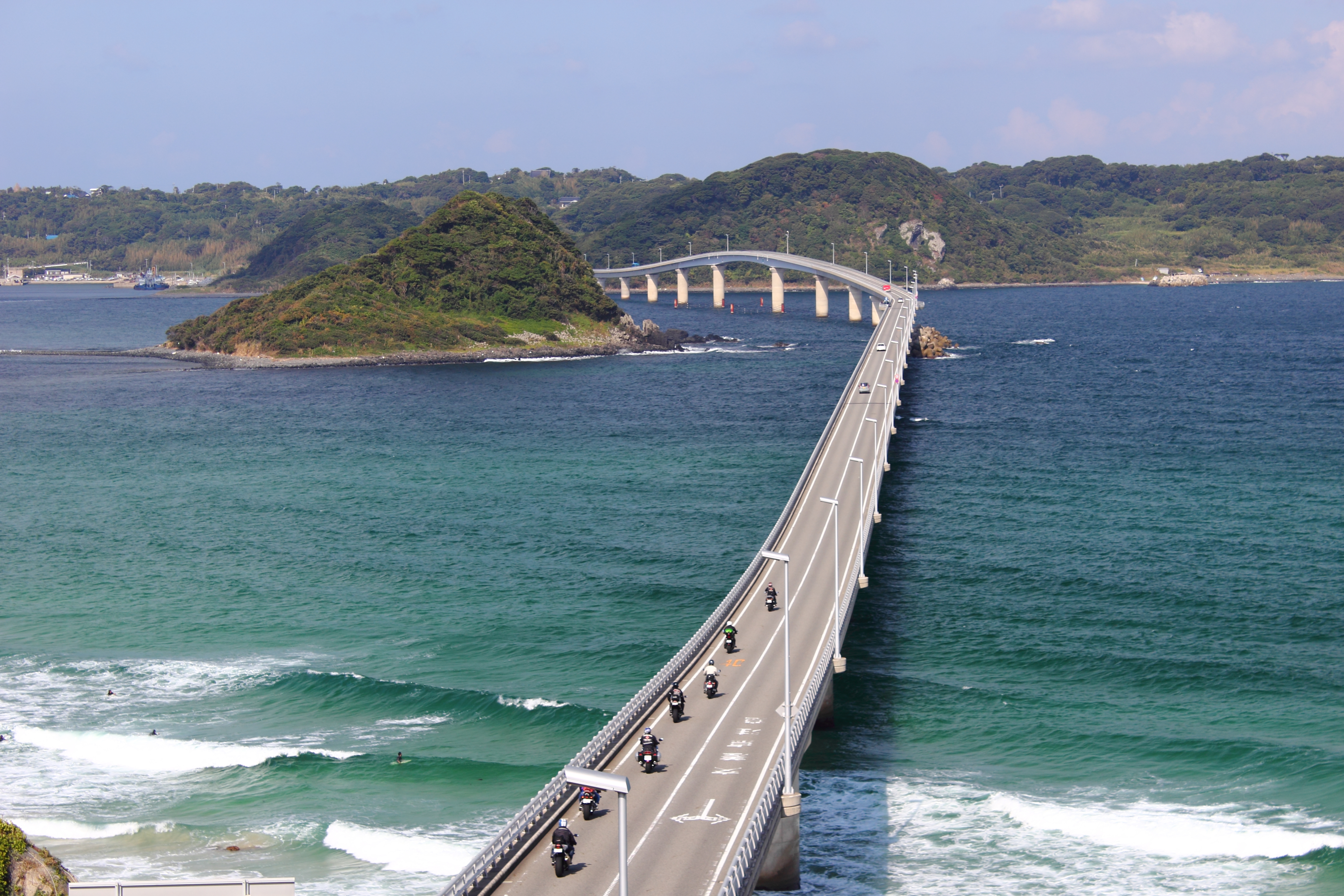
Tsunoshima Bridge (角島大橋, Tsunoshima Ōhashi) is a breathtaking 1,780-meter bridge that connects Tsunoshima Island to mainland Shimonoseki across the Amagaseto Strait in the Sea of Japan. Opened on November 3, 2000, after seven years of construction at a cost of ¥14.9 billion, it stands as the second-longest toll-free bridge to a remote island in Japan. 🔗
Late October offers ideal driving conditions with temperatures of 10-17°C, 61% clear skies, and excellent turquoise water visibility for photography. 🔗
Cultural & Historical Significance
The bridge's distinctive curved shape was deliberately designed to preserve the natural environment of Hatoshima, demonstrating an environmentally-conscious approach that earned it the Excellence Award from the Japan Society of Civil Engineers in 2003. Its limited bridge height maintains the landscape's aesthetic integrity while providing one of Japan's most photogenic driving experiences. 🔗
Tsunoshima Bridge has achieved legendary status as a filming location, frequently appearing in automobile commercials, television dramas, and movies due to its spectacular oceanscape and architectural beauty. 🔗 It was voted "Most Beautiful Bridge in Japan" on Trip Adviser and is recognized alongside nearby Motonosumi Inari Shrine, one of CNN's 31 Most Beautiful Places in Japan. 🔗
The bridge replaced a ferry service that operated seven daily round-trips but was frequently delayed by winter weather. Local residents advocated for the bridge's construction since 1983, and its completion transformed Tsunoshima from an isolated island into an accessible coastal paradise. 🔗
Visiting Information
Access: From Shimonoseki: About 1 hour by car from Shimonoseki IC on the Chugoku Expressway. Public Transportation: 1.5 hours by bus from JR Shimonoseki Station, or 15-minute bus ride from JR Sanin Main Line Kottoi Station. 🔗 🔗
Hours: Open 24/7 for bridge crossing; no operating hour restrictions.
Route Context: Closed to general passenger vehicles during strong wind conditions as a safety precaution. Check local weather forecasts, especially for late October when seasonal weather patterns can bring occasional strong winds. 🔗
Speed Limit: 40 km/h (25 mph) due to bridge's low height and proximity to water. 🔗
Parking: Free parking at all locations:
- Amagase Park (mainland viewpoint)
- Sesaki Akari Park (mainland)
- Shiokaze no Sato (island side visitor center)
Facilities:
- Restrooms available at Sesaki Akari Park (mainland) and Shiokaze no Sato (island)
- Food and drinks at Shiokaze no Sato (seafood, local specialties)
- Bicycle rentals at Tsunoshima Cycle Port: ¥200 for 2 hours (adults), ¥100 each additional hour 🔗
- Free Wi-Fi at Shiokaze no Sato 🔗
Seasonal Considerations: Late October provides excellent turquoise water visibility with lower summer crowds and comfortable temperatures. Autumn features: Dalmatian daisies bloom in Makisaki Kaze no Koen Park (late October to mid-November) at the island's northernmost point. 🔗
The Experience
The Bridge Crossing Experience
Driving across Tsunoshima Bridge is a mesmerizing experience as the road curves gracefully over turquoise and emerald waters. The 1,780-meter journey takes approximately 3-5 minutes at the required 40 km/h speed limit, allowing drivers and passengers to absorb the spectacular seascape. The bridge's gentle curve creates constantly changing perspectives of the island ahead and the open sea stretching to the horizon. 🔗
The water below shifts between vibrant shades of blue and green depending on weather and time of day, creating a Caribbean-like atmosphere rare in Japan. On clear days, the sea glows in shades of turquoise and emerald, with the bridge's white structure providing striking contrast against the cobalt blue waters. 🔗
Viewpoint Photography - Amagase Park
Before crossing, stop at Amagase Park on the mainland side for the iconic postcard view of the entire bridge. This observation platform offers the perfect vantage point to capture the bridge's full curved span stretching toward the island's green hills. The park features free parking and is the primary photography location for capturing the bridge in its entirety. 🔗
Additional viewpoints include Sesaki Akari Park, also on the mainland side, with a small parking lot, restrooms, and another perspective of the bridge. 🔗
Island Exploration - Tsunoshima Island
Once across the bridge, Shiokaze no Sato visitor center offers a large parking lot, orientation information, food, restrooms, and direct access to Cobalt Blue Beach. The facility operates like a roadside station with fresh seafood, local specialties, and meals with spectacular views. Hours: 9:00-17:00 (until 18:00 in July-August), dining 10:00-16:00 (last orders 15:30), closed Wednesdays. 🔗
Tsunoshima Lighthouse, one of Japan's oldest Western-style lighthouses (opened 1876), is climbable with 105-117 spiral stairs leading to panoramic 360-degree views. October-February hours: 9:00-16:30, last admission 16:10. The adjacent nature museum features the "Tsunoshima Whale" skeleton and exhibits on Kita-Nagato Kaigan National Park's flora, fauna, and geology. 🔗
Practical Visiting Tips
Photography Strategy:
- Stop at Amagase Park BEFORE crossing the bridge for the definitive wide-angle shot capturing the full curved span
- Visit on clear days for maximum water color vibrancy; cloudy/rainy conditions significantly diminish the visual impact
- Morning light (dawn to 10:00 AM) provides soft, warm tones ideal for photography
- Sunset photography offers dramatic sky colors behind the lighthouse silhouette
- The bridge is illuminated after sunset, creating romantic nighttime photography opportunities 🔗
Timing Recommendations:
- Quick Stop (20-30 minutes): Amagase Park photography + bridge crossing
- Standard Visit (45-60 minutes): Add Shiokaze no Sato visitor center, beach views
- Extended Exploration (2-3 hours): Include lighthouse climb, nature museum, coastal trails
Driving Considerations:
- Observe the 40 km/h speed limit; designed for safe viewing and photography
- Be aware of wind conditions, especially in autumn/winter months
- All parking is free at multiple locations
- The bridge may close to passenger vehicles during strong wind events - check local conditions before making the detour
Route Integration:
- Pairs naturally with Motonosumi Inari Shrine for comprehensive coastal scenic experience (approximately 30-40 minutes north)
- Represents transition from Yamaguchi's mountainous interior (karst plateaus) to dramatic western coastline
- Toll-free status and multiple viewpoints make it an accessible and photographer-friendly stop
Cultural Etiquette:
- Photography permitted throughout bridge and viewpoints
- Respect speed limits - designed for safety and scenery appreciation
- Leave no trace at viewpoint parks - carry out all trash
Budget Considerations:
- Bridge crossing completely toll-free (rare for such a long bridge in Japan)
- All parking facilities free
- Lighthouse admission minimal
- Bring picnic supplies to enjoy at beach areas rather than restaurant dining
Location: View on Google Maps
Source: attractions/kinosaki-to-fukuoka-yamaguchi-scenic-route/tsunoshima-bridge.md